
This section is The content in this section is supplied by GlobeNewswire for the purposes of distributing press releases on behalf of its clients. Postmedia has not reviewed the content. by GlobeNewswire Article content
HIGHLIGHTS
Sign In or Create an Account
or View more offersArticle content
5 shallow exploratory drill holes were completed on the West Zone of the Noyell property.
Article contentWe apologize, but this video has failed to load.Try refreshing your browser, or
tap here to see other videos from our team.Article content
This old gold showing area was never drill tested by Opus One before.
Article content
All drill holes intersected the main target over a strike length of 800 m.
Article content
All drill holes returned significant gold results above the 300 m level.
Article content
This represents the probable continuity of the gold mineralization on the neighboring property to the west.
Article content
Story continues below
This advertisement has not loaded yet, but your article continues below.
Article content
The West Zone will become another area where definition drilling should be performed during the next phase of work.
Article contentArticle content
MONTREAL, Sept. 02, 2026 (GLOBE NEWSWIRE) — Opus One Gold Corp (TSX-V: OOR) (the “Company” or “Opus One”) is pleased to release more assay results from the 2026 drilling program on its 100% owned Noyell property located in the northern portion of the Abitibi greenstone belt near the town of Matagami, Quebec, Canada.
Article content
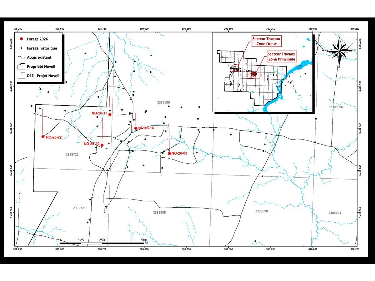
Opus One finally received all assay results from the drilling completed over an 800 m strike length in the western portion of its Noyell property. This old gold showing area was never drill tested by Opus One before. A total of 5 shallow exploratory drill holes (1,467 m) were completed over the sector to test for potential economic gold mineralization. As it was a preliminary drill program, the goal was not to carry out definition drilling but to get a better understanding of the gold environment which is quite different from what we observe at Zone 1 (center of the property) even though, the gold mineralization appears to be found along the same favorable structure
Article content
Story continues below
This advertisement has not loaded yet, but your article continues below.
Article content
DRILL HOLE COORDINATES
Article contentHole NumberEastingNorthingBearingDipLength (m)NO-26-09309150,005488350,00358-63372NO-26-16308950,005488500,00359-55150NO-26-17308800,005488580,00359-62207NO-26-20308750,005488400,00358-68330NO-26-22308400,005488450,00358-71408 Article content
ASSAY RESULTS
Article contentDDHZoneFromToLength (m)True WidthAu (g/t)NO-26-09Zone 1 Ouest240,42249,328,96,851,03NO-26-09Zone 2 Ouest268,06269,251,190,923,48NO-26-16Zone 1 Ouest110,17120,5810,418,730,50NO-26-17Zone 1 Ouest75,2979,253,963,071,11NO-26-20Zone 1 Ouest271,18279,478,296,431,34NO-26-22Zone 1 Ouest295,13304,29,076,621,18NO-26-22Zone 2 Ouest325,14330,275,133,770,71 Article content
DRILL HOLE LOCATION MAP – ZONE WEST
Article contentArticle contentArticle contentArticle content
Geologically speaking, Zone West is underlain by alternating bands of sheared sediments and volcanics dipping to the south at -55°. The gold mineralization is observed in a possible mylonitic zone within fractured intermediate volcanics. A fair amount of sulphides (5 – 15% mostly pyrrhotite with minor pyrite and arsenopyrite) is observed within the altered package (chlorite, graphite, silica, ankerite). This environment differs significantly from Zone 1 (central area) which consists of a quartz, ankerite and semi massive sulphide stockwork within an altered but not sheared sedimentary package. The dip is also steeper (-67°S).