
Winter delivers record low snow and unprecedent warmth to Australian AlpsBy ABC meteorologist Tom Saunders
Posted Thu 3 Sep 2026 at 6:04amThu 3 Sep 2026 at 6:04amThu 3 Sep 2026 at 6:04am
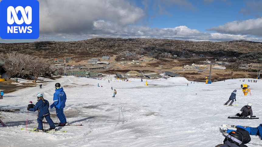
Australian ski resorts are winding up operations early in 2026 after the warmest winter on record.
Along with mild temperatures, winter also brought frequent rain to the high country, leading to the complete failure of a seasonal snowpack to become established across lower alpine elevations.
This year now also marks three very lean years out of the past four, continuing the long-term decline in snowfall across the Australia Alps which is proving to be one of the most tangible signs of our warming climate.
Ski fields above freezing most of winter
This year’s snow season was a challenge from the start.
June was unseasonably warm and wet, and when it was not raining, it was mostly too warm for snowmaking at ski resorts.
A remarkable statistic for early winter was the Perisher Valley weather station measured 301 millimetres of precipitation from June 1 to July 2, of which only 25mm fell at a temperature below 0 degrees Celsius.
A modest dump of snow finally arrived in July, but in general the month was still mild and occasionally rainy, and although a snow base was able to develop on higher slopes, a full cover across lower alpine regions was never able to form.
Last month brought no relief with further rain and above average temperatures — during the final days of the month, alpine maximums even climbed above 10C, including a new all-time winter record of 14.4C at Perisher on Saturday, August 29.
Three warmer than normal months meant the average winter temperatures across the high country were easily the highest on record, and by a fair margin.
The longest running BOM station in the Australian alpine region is Cabramurra where this winter’s mean of 4.0C was well above the long-term average of 1.8C and nearly half a degree above the previous record in 2023.
Across the border, the Mount Buller station has been operational since 1985 and also exceeded the previous record by nearly half a degree, coming in at 1.9C versus a long-term average of 0.1C.
Snow depth in 2026 historically low
Before: Pictures of Frostbite Kiosk at Thredbo on August 30, 2025, versus August 30, 2026.. . After: (Supplied). .
Instructions: Use left and right arrow keys to control image transition
SLIDE
In a typical year, snow accumulates through winter and reaches a peak depth in August or early September.
However, this year, discounting the improbable arrival of a major polar storm this spring, snow peaked two weeks earlier than average and was at historically low levels, which heavily restricted the amount of open terrain for skiing.
The table below shows the peak snow depth in 2026 compared to on average, however there are a few caveats when analysing snow data in Australia*.
What is evident this season is for higher elevations it was the worst season for natural snow since 2006, while for lower regions it was the worst on record.
Despite the setbacks, CEO of Snow Resorts Australia Josh Elliott was confident the industry had the infrastructure to mitigate poor seasons.
“While conditions and available terrain have differed between resorts, continued investment in snowmaking and snow management has meant that skiing, snowboarding and snowplay have been available in NSW, Victoria and the ACT since the June long weekend,” he said.
But even extensive snow curation lost out to the elements eventually, and two of the lower resorts Mount Selwyn and Mount Baw Baw already shut down operations for the season a fortnight ago.
Mount Hotham is also due for a premature finish this Sunday, and with more heavy rain ahead this weekend, it is hard to see the other major resorts lasting until the traditional closing weekend in early October.
The downhill slide continues
In isolation, a winter without much snow is nothing new in Australia — 1973 and 1982 were both very lean years — but it is the sharp downward trend over recent decades that is concerning.
And unsurprisingly, it is the marginal lower alpine areas which are most vulnerable to a warming climate, since more winter precipitation is now falling as rain, and above freezing temperatures are melting the snow cover between storms.
Between 1955 and 2000, the peak annual snow depth at Three-Mile Dam, at an elevation of 1,460 metres, averaged 55 centimetres, but during the past 25 years that figure has fallen to 34cm, a reduction of 38 per cent.
A few hundred metres higher, Mount Buller’s drop during the corresponding period is 21 per cent, from 117cm to 93cm, while for Spencers Creek at 1,830m, the decline is 13 per cent from 205cm to 178cm.
In other words, the winter snowline is clearly rising, and projections from several studies this century show that by 2050, maximum snow depth at major resorts, relative to the late 20th century, may decline by more than 50 per cent even under a low emissions scenario.
However Mr Elliott said Australian resorts were leveraging against future climates.
“While those projections may be relevant to understanding changes in the natural alpine environment, they are not forecasts of future skiable terrain, resort operating periods or the visitor experience,” he said.
“Snowmaking has been a core component of the Australian snow experience for more than 35 years. New technology, including All-Weather Snowmaking Systems, now allows resorts with these systems to produce snow in ambient temperatures of up to +20C.”
*Victorian statistics are sufficiently robust with daily natural snow depth readings taken by resorts; however, Mount Hotham did not report during the COVID-19 winters of 2020 and 2021. In NSW, Perisher and Thredbo quote the snow depth taken by Snowy Hydro at Spencers Creek, normally measured weekly or fortnightly. Snowy Hydro also takes readings at Deep Creek and Three-Mile Dam, however these datasets suffer from inconsistent measurement intervals, with intervals between readings of up to three weeks.